Eleven Winston-Salem areas from Old Salem to Old Town: ZIP codes, zoned high schools, August 2026 home values and how school zones split neighborhoods.
Last checked Oct. 12, 2026. Sources: the City of Winston-Salem’s Legacy 2030 area plans, local historic districts page and GIS map layers for city limits, school zones and parks, the N.C. State Historic Preservation Office, the N.C. Department of Public Instruction’s 2025-26 accountability data, the U.S. Census Bureau, OpenStreetMap and Zillow Research.
Winston-Salem covers about 86,500 acres, roughly 135 square miles, according to the city’s corporate limits map layer, and had 252,037 residents in the Census Bureau’s 2020-2024 American Community Survey (QuickFacts). It is the county seat of Forsyth County. The city formed in 1913 when Salem, the Moravian town that is now Old Salem, combined with Winston to its north, according to NCpedia; more in our history guide.
Four things shape where people live:
- The main roads. Salem Parkway, the former Business 40, carries US 421 and US 158 across the city just south of downtown. US 52 runs north-south on downtown’s east side, I-40 crosses the south side, and Silas Creek Parkway curves around the west. See our getting around guide.
- ZIP codes. The main city ZIP codes are 27101 (downtown, the West End, Old Salem and East Winston), 27103 (Ardmore and the southwest), 27104 and 27106 (the west and northwest), 27105 (the north), 27107 (the southeast) and 27127 (the south). Parts of 27040, 27109 and 27110 are also inside the city.
- School zones do not follow neighborhood lines. Winston-Salem/Forsyth County Schools is one countywide district that assigns schools by address. Waughtown, Old Town, Sherwood Forest and East Winston are each split between high school zones. Confirm any address with the district at 336-727-2292.
- The city’s area plans. City-County Planning divides the city and county into area plans, adopted between 2012 and 2018, plus the 2023 Downtown Winston-Salem Plan. Many neighborhood names in this guide come from those plans and from the city’s National Register historic districts.
The areas at a glance
Zoned high school is the one most of the area was zoned for on the city’s school zone maps; check every address with the district. Home value is the Zillow Home Value Index for the area’s main ZIP code in August 2026, a modeled typical value for the middle third of homes, not a sale price.
| Area | ZIP code | Zoned high school | Home value, Aug. 2026 | Guide |
|---|---|---|---|---|
| Downtown | 27101 | R.J. Reynolds | $226,961 | Downtown |
| West End | 27101 | R.J. Reynolds | $226,961 | West End |
| Old Salem | 27101 | R.J. Reynolds | $226,961 | Old Salem |
| Washington Park | 27127 | Parkland | $257,595 | Washington Park |
| Ardmore | 27103 | R.J. Reynolds | $279,442 | Ardmore |
| Buena Vista | 27104 | R.J. Reynolds | $372,421 | Buena Vista |
| East Winston | 27101 | Carver (split) | $226,961 | East Winston |
| Waughtown | 27107 | Glenn (split) | $244,448 | Waughtown |
| Konnoak Hills | 27127 | Parkland | $257,595 | Konnoak Hills |
| Sherwood Forest | 27106 | Mount Tabor (split) | $333,936 | Sherwood Forest |
| Old Town | 27106 | North Forsyth (split) | $333,936 | Old Town |
The figure for the whole city was $263,057, up 0.2% in a year. ZIP code trends are on our home prices page, and school results on our schools guide.
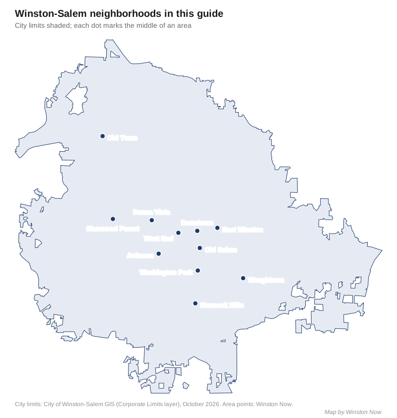
Map
Downtown
The city center inside Salem Parkway and US 52, with Fourth Street, the Arts District, Industry Hill and the Innovation Quarter named as its core districts in the 2023 downtown plan. Apartments and condominiums; zoned mostly for R.J. Reynolds High. Read the Downtown guide.
West End
The hillside streetcar suburb laid out in 1890 on downtown’s western edge, a National Register and local historic overlay district, with Hanes Park. Zoned for R.J. Reynolds High; ZIP code 27101. Read the West End guide.
Old Salem
The Moravian town south of downtown, a National Historic Landmark and the state’s first locally zoned historic district, with homes, museum buildings and Salem Academy and College. Zoned for R.J. Reynolds High. Read the Old Salem guide.
Washington Park
Early 20th-century houses around the 77-acre city park of the same name, a National Register district south of Old Salem. Zoned for Parkland High; ZIP code 27127. Read the Washington Park guide.
Ardmore
The city’s “first automobile suburb,” in the city’s words, between Salem Parkway and Silas Creek Parkway, with Miller Park and the hospital campus on its edge. Zoned for R.J. Reynolds High; ZIP code 27103. Read the Ardmore guide.
Buena Vista
A suburb of the 1910s and 1920s along Buena Vista Road on the west side, mostly zoned for Whitaker Elementary and R.J. Reynolds High, in ZIP code 27104. Read the Buena Vista guide.
East Winston
The area east of US 52 and downtown around Martin Luther King Jr. Drive, with Reynoldstown, Union Station and the Malloy-Jordan East Winston Heritage Center library. Mostly zoned for Carver High. Read the East Winston guide.
Waughtown
The old Plank Road community along Waughtown and Sprague streets southeast of downtown, a National Register district with Sprague Street Park and the Quarry at Grant Park. Zoned for Glenn, Parkland or East Forsyth High. Read the Waughtown guide.
Konnoak Hills
Homes along Konnoak Drive south of I-40, near Parkland High and the Southside Branch Library. Zoned for Parkland High; ZIP code 27127. Read the Konnoak Hills guide.
Sherwood Forest
The west-side suburban area around Yorkshire Road and Shaffner Park, with shopping on Robinhood Road. Split between Mount Tabor and R.J. Reynolds high schools and ZIP codes 27106 and 27104. Read the Sherwood Forest guide.
Old Town
The northwest area along Reynolda Road, from Old Town Elementary to Historic Bethabara Park, the site of the Moravians’ first settlement. Split among North Forsyth, Mount Tabor and Reagan high schools. Read the Old Town guide.
Comparing towns
To compare Winston-Salem with Walkertown, Clemmons and Lewisville on taxes, schools, home values and commutes, see Winston-Salem vs Walkertown vs Clemmons vs Lewisville. Property tax details are in our property tax guide and parks in our parks and trails guide.
How we built this
We named an area only when a public source names it as a place:
- The city’s area plans. The Downtown Winston-Salem Plan, the South Central plan (Old Salem, Washington Park), the Southwest plan (Ardmore), the Northwest plan (Buena Vista), the East-Northeast plan (East Winston), the South Suburban plan (Konnoak Hills), the West Suburban plan (Sherwood Forest, Old Town) and the North Suburban plan (Bethabara and Old Town).
- Historic districts. The city’s local historic districts (Old Salem, the West End) and the National Register districts mapped by the state historic preservation office (Ardmore, Washington Park, Waughtown-Belview), whose outlines we used for those areas.
- OpenStreetMap. OpenStreetMap names Ardmore, Buena Vista, East Winston, Waughtown, Old Town and Oldtown as places. Where no boundary is published, we used a circle of half a mile to about a mile around the named place.
School zones come from the city’s published school zone map layers, checked at evenly spaced points in each area, and test results from the state’s 2025-26 accountability data. ZIP codes come from the Census Bureau’s ZIP code tabulation areas. Distances were measured on OpenStreetMap roads with the OSRM routing engine, and bus routes come from WSTA’s schedule data for the routes that took effect Aug. 30, 2026.
The plans name many more neighborhoods than this guide covers, including West Highlands, Westview, Hanestown, Happy Hill, Sunnyside, Holly Avenue and West Salem. The city keeps a voluntary neighborhood association registry, which it says is not a legal record; we found no public list of homeowners associations, so the area guides do not describe them.
Frequently asked questions
What are the neighborhoods in Winston-Salem, NC?
This guide covers 11 areas named in the city’s area plans, historic district records or OpenStreetMap: Downtown, the West End, Old Salem, Washington Park, Ardmore, Buena Vista, East Winston, Waughtown, Konnoak Hills, Sherwood Forest and Old Town.
What ZIP codes are in Winston-Salem?
The city’s main ZIP codes are 27101, 27103, 27104, 27105, 27106, 27107 and 27127. Parts of 27040, 27109 and 27110 are also inside the city.
Which Winston-Salem ZIP code has the highest home values?
In August 2026 Zillow’s Home Value Index was highest in 27104 on the west side, at $372,421, followed by 27106 at $333,936. The figure for the whole city was $263,057.
Do Winston-Salem school zones follow neighborhood lines?
No. Winston-Salem/Forsyth County Schools draws zones by address, and several neighborhoods are split. Waughtown is zoned for three different high schools and Old Town for three. Confirm an address with the district at 336-727-2292.
Have your say